Matrix
Integrated Traffic Data Management System
IT project case by Transparen
Matrix
Developed by TransparenProject overview
Transparen implemented MATRIX at the request of The Regional Municipality of Durham, Ontario, Canada in cooperation with the Traffic Engineering and Operations department.
The client required software to store, process, display, and report traffic related data to support the day-to-day operations, planning and policy development of the Region’s road network.
In close cooperation with GIS Specialists and Data Management Coordinators we collected and combined into a single web application all requirements of the Traffic Engineering and Operations department.
MATRIX is an Integrated Traffic Data Management System (ITDMS). It is integrated with the police regional database. It processes road sensor data and displays it on an intuitive and easy-to-use (ESRI) GIS map-based graphical user interface.

Deliverable
Functional and bug-free web application

Industry
Traffic Engineering

Solution
Integrated Traffic Data Management System with GIS-Based Map-Driven UI

Tech stack
JavaScript, PHP, MsSQL, Oracle, ArcGIS API, Git

Team
6 (1PM, 3 Devs, 1QA, 1UI)
Matrix
Developed by TransparenProject overview

The project goal was to engineer and operate a safe and efficient road network that effectively meets the requirements and expectations of residents and business owners in the Region of Durham:
- Reduce the transit travel demand impacted by anticipated capacity deficiencies and congestion
- Improve traffic safety based on the opportunity to reduce congestion and potential for collisions
- Maintain long-term consistency with the proposed transportation system and roads
- Address walking and cycling objects in the corridor (sidewalks, bike lanes, on-road routes, etc.).
- Improve response time/accessibility for emergency and fire vehicles due to the changes in travel time
Intelligent Traffic System
Developed by TransparenProduct Features
Map-based UI
Access to system functions and zoom levels defined for all traffic network elements
GIS map utilization
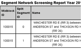
Management of the road segment and intersection attributes
Custom search engine
Accurate implementation of search zoom level. Collects map object’s coordinates from the ArcGIS map server and converts degrees to meters
Integration with road sensors
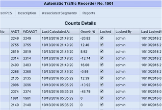
Collection of data from 3 types of traffic counts from road sensors
Provides calculation of the specifiс domain indexes and predictions based on the collected data and algorithms.
Average Annual Daily Traffic (AADT)
Weekday Average Annual Daily Traffic (WAADT)
Potential for Safety Improvement (PSI)
Safety Performance
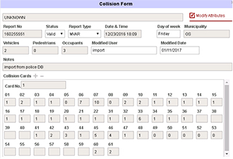
The collision report system is integrated with the police department database to collect collisions data and it generates reports.
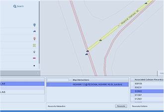
The reconciliation functionality reconciles the temporary map objects and collisions data with roads and intersections which were in the process of development or reconstruction.
The system predicts the situation on the roads for the next 7 years, which makes it possible to relieve traffic on the major road arteries and accurately plan the construction of new road sections and intersections.
Intelligent Traffic System
Developed by TransparenMethodology and Tools
Methodology: Waterfall
Reporting: Weekly demos
Tools

used for meetings
with the Client

used for internal team
communication
Intelligent Traffic System
Developed by TransparenTechnical Expertise
Transparen's team uses the latest technologies to optimize the development process


Intelligent Traffic System
Developed by TransparenProject Challenges

The database structure often needed changes to support new modules. The solution was to write a library that made it possibleto make only necessary updates to the table structure, without losing data. This library also allowed automatic support of other RDMS databases such as MSSQL, MySQL, PostgreSQL and Oracle, which helped to speed up development, and which provided other safety features such as automatic backups, deployment of necessary data, and clean updates of the database structure without impacting existing data.
We created a custom Js Controller for the Search Module. It can be used as a template to implement similar search in ArcGIS. This will allow us to speed up the development of other projects that use the ArcGIS API.

About Us
Transparen is a software development shop which helps SMEs and startups build digital products. We are your CTO with a managed project team.
Founded in 2003 we grew to more than 100 people and helped partners from Canada and the USA launch their businesses. Originally from Canada and operating in Texas, New York, and Ukraine, our team combines a Western entrepreneurial mindset with strong analytical and problem-solving skills of Ukrainian developers. We are entrepreneurs just like many of our clients and know how to create solutions that work to achieve entrepreneurial objectives.

UI/UX design
We deliver native and cross platform iOS and Android apps tailored to provide the best user experience


DevOps

We offer sleek & stylish solutions for user-friendly apps and responsive web designs

Mobile apps
We automate the process of software delivery and infrastructure changes

UI/UX design
We provide business analysis, design and development of custom web applications

DevOps
We create clickable product prototypes to help you pitch your ideas to investors

Web apps
We ensure the on-time release of bug free software

Transparen’s team is happy to speak with you and tell you more. To request the demo or ask a question, please contact

Case Jones
founder+ 1 888 887 3102
cjones@tcgsi.com
www.linkedin.com/in/casejones
www.transparen.com